
Mongolian Geology
Mongolia and Northern China were formed by a series of accretionary terrains that range in age from Proterozoic to Late Palaeozoic as shown in Figure 1.
Each successive accretionary belt was added from the south and wrapped around the Siberian Craton to the north, forming a series of concave north-wrapping arcs separated by ophiolitic suture zones. Two suture zones are present in Mongolia, the Baikalian Lineament in the north, which represents late Proterozoic accretion and the Main Mongolian Lineament in the south, which represents Silurian accretion. In southern Mongolia, the oldest rocks are of late Precambrian to middle Palaeozoic age and were deposited as shallow marine carbonate and clastic facies, on passive continental margins. Mid-Palaeozoic orogenesis is associated with the collision of the Altai microplate in western Mongolia and the accretion of the central Mongolian microplate onto the Siberian Craton. Renewed sedimentation in the Altai foreland and also perhaps in marginal rift or back arc basins is represented by Devonian and Carboniferous continental and marine clastic and volcanic formations.
A Late Carboniferous to Early Permian orogenic phase marks accretion of the Gobi microplate onto the enlarged Mongolian-Siberian Craton, giving rise to a third suture which more or less coincides with the location of the present day Mongolian-Chinese border.
Late Permian to Early Jurassic sediments in southern Mongolia comprise a very thick sequence of coarse continental clastic formations overlain by locally occurring finer clastic, coal, and lacustrine sequences possibly deposited in foreland basins. These sediments were subsequently deformed during the Triassic to Middle Jurassic, when the Qiantang block (in China), collided with
the growing Mongolian-Siberian Craton.
Later periods of continental rifting occurred resulted in thick sequences of fluvial conglomerate and sandstone, floodplain coal, and lacustrine shale to be deposited in the rift basins through the Late Jurassic and Early Cretaceous. The southern Mongolia area was affected by significant tectonism and volcanic activity throughout the Late Cretaceous and Tertiary periods.

Figure 1: Regional Tectonic Setting
TTCBM Project
Jade’s flagship project is the TTCBM Project.
Jade’s joint venture partner, EM, was awarded a PSA over the TTCBM Project area in April 2020, after completion by MGR of the requirements of a Prospecting Agreement held by JV partner EM over the area. In accordance with the joint venture agreements, Jade managed, fully funded and operated the fulfillment of the PSA requirements during that period. Following approval of the Cabinet of Mongolia in October 2020, the PSA rights and obligations were fully transferred to the joint venture company MGR.
Jade has completed drilling seven wells in the Red Lake area, with extensive gas bearing coals extracted through coring. The extent of the gas bearing coals in the wells averages around 60 metres, and up to 124 metres. As well as this, gas composition findings from delivered methane of 98% in coal seam III and 0, and 92.5% in coal seam IV. High gas content readings were also identified ranging from 12-18 m3 per tonne.
The Company announced the booking of a Gross unrisked 2C Contingent Resource of 246 Bcf. This booking was for the Red Lake area only and is a significant milestone as the project moves towards pilot production in 2023. Of note is that the Red Lake area is a relatively small portion of the prospective area within the TTCBM Project permit.
The TTCBM Project gas play was extended some 25 kilometres to the east of the Red Lake area with the successful drilling of the Vista-1 and Brownhill-1 exploration wells. The wells intersected 38 metres and 41 metres of gassy coal l, respectively.
Local Structural Geology
The coal seams of the Tavan Tolgoi district accumulated in the Ulaan Nuur Trough, an intra-cratonic basin. The basin, generally regarded as a broad synclinorium, is the result of crustal subsidence of the basement rock adjacent to a large scale east to northeast trending fault system (mega-shear) that bounds the district to the north. Upper Permian coals accumulated in the subsiding basin and were subsequently faulted and folded from a moderate to intense degree by post-depositional tectonic events.
The Tavan Tolgoi coalfield is comprised of a series of east-west trending synclines and anticlines which are overprinted by a north-south trending anticline. While much of the Tavan Tolgoi is gently to moderately inclined, dips in the flanks of these structures can exceed 40°. Numerous east-west trending normal faults bisect the coalfield. Significant east-west trending thrust faults form the coalfield boundaries throughout much of Tavan Tolgoi, bringing underlying, older volcanics and non-coalbearing formations to the surface and truncating the coal resource areas.
Figure 3 shows the structural features of the Tavan Tolgoi coalfield. The areas of the coal-bearing formations are shaded. Two major fold structures are evident in the western half of the deposit, the Tsankhi Syncline and Tsankhi Anticline. The syncline hosts the structural basin containing the thickest coal-bearing sequence, while the anticline brings the lowest coal horizons to the surface.

Figure 2: TTCBM Project Area
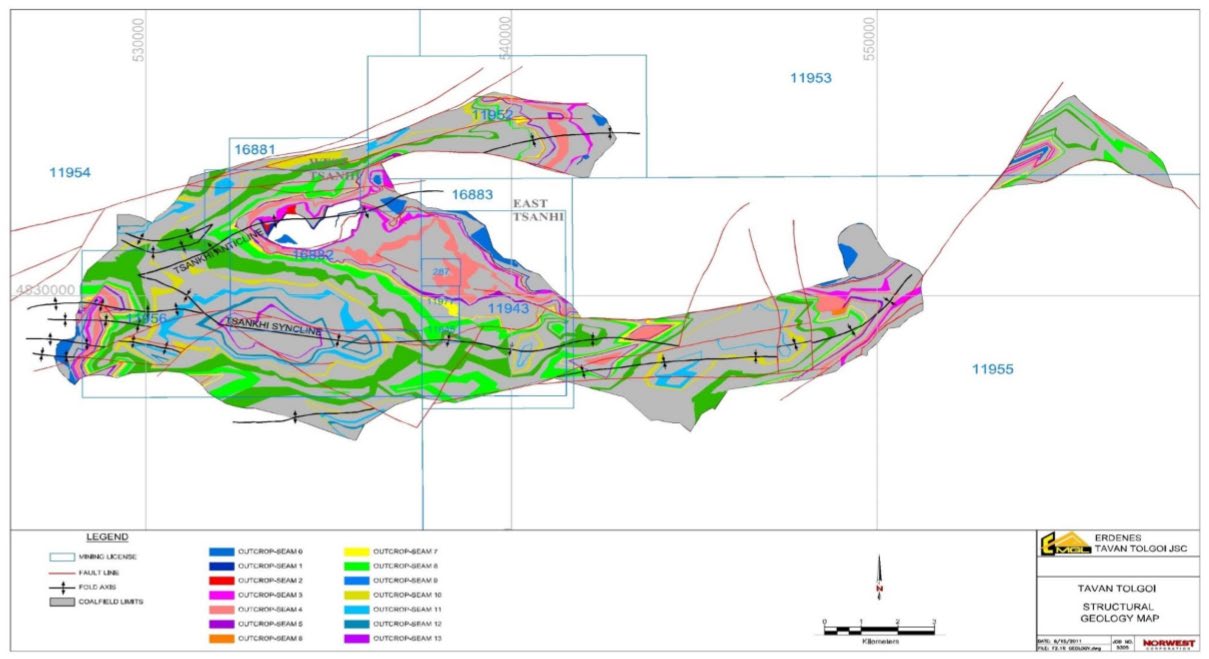
Figure 3: Structural Geology Map
Shivee Gobi
Jade has 100% of the Shivee Gobi prospecting agreement permit (PA), which covers an area of 8,317 km2 and is located approximately 300 kilometres south of Ulaanbaatar. Within the permit are several known coal deposits, primarily trending from north-east to south-west.
Minimal expenditure commitments on the Shivee Gobi PA over a three-year prospecting period have been negotiated. It is expected that initial desk top study work will be completed around mid-2022 to better assess its potential, ahead of technical studies, drilling, coal sampling and gas testing. Total expenditure for the three-year period is initially estimated at around US$110k.

Eastern Gobi
Jade has 100% of the Eastern Gobi PA, which covers an area of 9,691 km2 and is located approximately 450 kilometres south of Ulaanbaatar. The Eastern Gobi PA is home to significant coal deposits that are highly prospective for CBM.
Minimal expenditure commitments over a three-year prospecting period for the Eastern Gobi PA have been negotiated. It is expected that initial desk top study work will be completed around mid-2022, with total expenditure for the three-year period initially estimated at around US$160k.

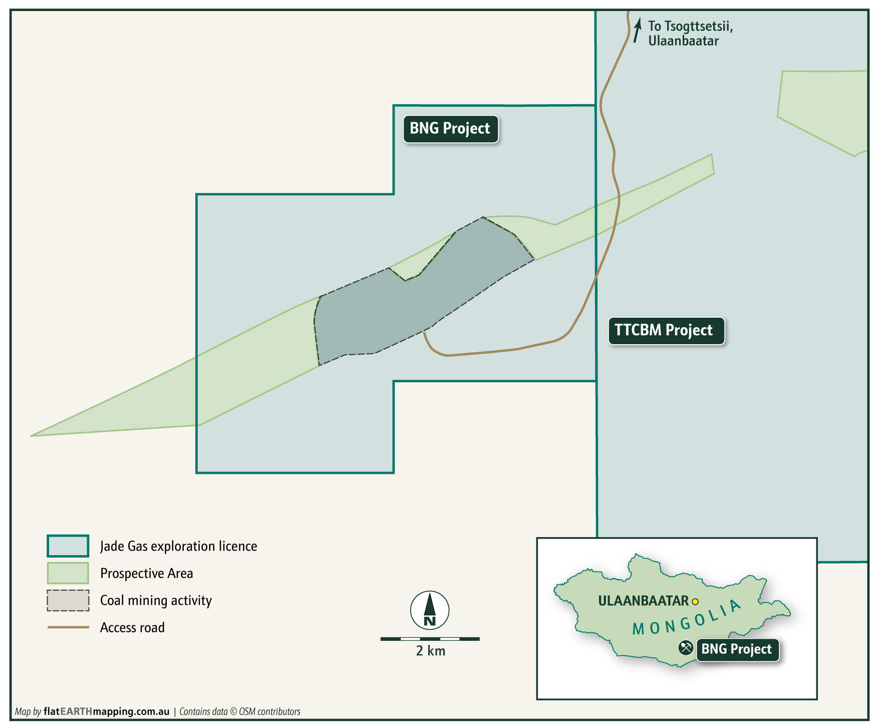
Baruun Naran
Jade has 66% of the highly prospective Baruun Naran PA, with Khangad Exploration LLC (subsidiary of Mongolia Mining Corporation – HKSE:0975) having 34%. The permit is located adjacent to the TTCBM Project, with an existing coal field in it (410 Mt JORC compliant coal resource), and is a continuation of the Tavan Tolgoi coal basin.
Minimal expenditure commitments over a three-year prospecting period for the Baruun Naran PA have been negotiated. The PA comes with a dataset of historical drilling which will guide an upcoming drilling program. Total expenditure for the three-year period is initially estimated at US$160k.
Jade completed drilling the BNG-1 and BNG-2 wells, with BNG-1 reaching a measured depth of 463 metres. The BNG wells are targeting shallow coals at depths of between 150 and 350 metres, with BNG-1 recovering 35 metres of gassy coal.
The BNG-2 well was successfully drilled to a measured depth of 592 metres, with 26 metres of gassy coal core recovered between 471 to 530 metres.
The success of the BNG wells has now extended the TTCBM Project gas play to the west.